It’s a lake.
The water can’t go anywhere.
Nothing changes right?
Wrong!
Summer Time
You’re sitting in your Lake Norman backyard, on a quiet cove, water splashing against your seawall. You dive into 8 feet of refreshing lake.
Life is good.
Winter Time
You’re sitting in the backyard, on a quiet cove, you notice the lack of water splashing. You walk out to dive in and there’s only 3 feet of water and about 2 feet of mud where water used to be.
Life is still good, but less good…had you not known this could happen with your property.
Water Levels Change
Water level changes can have a huge impact on your waterfront home and the lifestyle you plan on living here. Let’s break down some basic information about the water level on Lake Norman.
All year long, month to month, season to season. But don’t worry, it’s controlled and planned by Duke Energy. They manage the dam that controls the flow of water out of Lake Norman.
100 ft
When Lake Norman is full to the MAX, it’s at 100-ft deep or “Full Pond”. Anything more is considered flooding.
760 Line
When Lake Norman is “Full Pond”, then the water hitting your toes at the shoreline is “760” feet above sea level. This line is important for waterfront Lake Norman homes because it is the boundary where Duke Energy has control of your property vs local and state regulators.
98 ft
This is the target height of the water during the busy summer season (yay!). Duke wants to leave some wiggle room or major storms and increased waves from you doing cannonballs off your dock.
94 ft
This is the target height of the water during the slow winter season. Duke needs to room in the lake to gather winter melting snow from the mountains and spring storms.
91 ft
When Lake Norman is getting very low the min is at 91-ft deep. Anything less is considered drought.
Check Levels, then House Hunt.
When you’re looking at Lake Norman waterfront property, it’s important to check the current water levels and the history on Dukes Website. This way you’ll know how much better or worse the shoreline will be in the summer vs. winter.
In winter, you’ll need to imagine the water 4 feet higher. And in summer, you’ll need to imagine it 4 feet lower.
Topography Maps
When buying a waterfront Lake Norman home, you’ll find yourself using some skills you thought you’d never need. Checking topography “elevation” maps around the shoreline and dock area of the home you’re looking at is important.
The Tale of 2 Waterfront Homes
This maps shows the elevation for 2 neighbors. (I’ve highlighted and added the elevations for readability.)
Imagine both are for sale, which would you choose?
98 ft
As we know from above, this is the target height of the lake during summer months. Both homes have lots of usable backyard landscape and good water access.
100 ft
The max height of the lake. This can get hit a few times during the summer if big storms roll in non-stop. Think hurricane off the coast. Notice both waterfront homes could get swampy for a day or so if Duke doesn’t let the water out of the lake fast enough.
102 ft
This would be a flood (we will discuss in more detail below). Though rare, look at the difference in impact to the waterfront Lake Norman homes. The left will have some lake water in the pool, nothing major… the right will have water damage to the home itself.
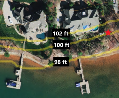
See how important this is?
It will impact your flood insurance premium, your decisions to build pools, seating areas, fire pits, etc…
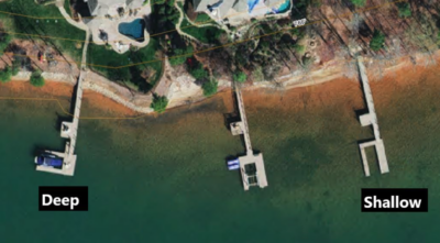
Dock Length
The length of the dock can dictate the different levels of water you’ll have for water activities. Most likely the far end of the dock will be deep(er) water (enough for a boat to operate in).
You can use a topography map, or at minimum, any aerial photography to see the water shading. Notice the drastic difference from the previous waterfront Lake Norman homes.
Flooding
Even though the water level is controlled, that doesn’t mean it can be let out fast enough.
There are many areas downstream (and upstream) of Lake Norman and it’s a complicated process managing the water.
Any waterfront Lake Norman home for sale is likely classified in a floodplain by FEMA or the local county.
1% Chance Flood
Statistically, a waterfront Lake Norman home has a 1% chance of flooding in any given year (or 26% chance over the life of a 30 year mortgage). Almost all waterfront homes are in the FEMA flood zone “AE”. Also called a “100-year” flood or “base flood”. This 1% chance flood is the standard for flood insurance requirements and floodplain development restrictions.
Don’t worry, typically it will be for parts of the yard and not the home itself, but it’s good to verify with FEMA and local flood plain maps.
Highest Historical Levels
- 100.93 ft on 09/09/2004
- 100.50 ft on 10/02/1988
- 100.50 ft on 10/23/1990
Flood Stages
- 100 ft – Action Stage
- 102 ft – Flood Stage
- 105 ft – Moderate Flood Stage
- 110 ft – Major Flood Stage
Protocols
As the historical #’s show, Lake Norman has never been over 101 ft, but these protocols do exist:
- 100 ft – Flooding along shoreline and downstream of dam will begin.
- 101 ft – Action Stage Continues. Docks and yards may begin to flood. Primary flood impacts may be below Cowans Ford Dam. Flood Advisory likely.
- 102 ft – Flooding of docks and low lying areas along shoreline flooded and some homes below the dam flood.
- 105 ft – Moderate flooding of homes along shoreline and in vicinity of dam begins.
- 110 ft – Major flooding begins. Homes and bridges downstream of the dam may be affected.
- 115.5 ft – all gates open AT this level.
Flood Insurance & Mapping
FEMA and the local counties around Lake Norman have detailed flood maps for every waterfront Lake Norman home.
Notice the 3 neighbors on this map…Let’s look at the details for each.
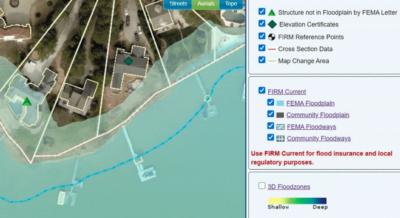
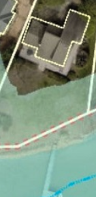
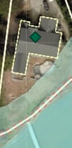
Home 1
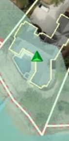
Notice the flood water overlay completely covers the home, this is a problem right? No, see the small green triangle on it?
FEMA issued an official “Structure not in Floodplain” letter saying the home is no longer in danger. This is common for a new build, the land was graded higher than the floodplain to solve the issue.
Home 2
The yard gets covered in a flood, but the home is safe.
So do they need flood insurance? Not likely, the county will state: “FEMA floodplain (Zone AE) on property. Flood insurance required if the building in floodplain”. Keyword “building”.
Home 3
Notice the flood water touches the corner of the home. But see the small green diamond now?
This means they had a survey and have an “Elevation Certificate” from FEMA stating that area of the home is not in danger. This can be achieved with a land survey to get exact measurements in those areas.
Drought
Another concern is the extreme opposite of flooding. Water levels on Lake Norman can get lower than Duke Energy would like.
This has happened a few times in the past and it is equally important to know how your waterfront Lake Norman home will be impacted.
Topography Maps and Aerial Imagery
It’s the same as everything you just read above, but in reverse looking at lower elevations.
You may want to ask yourself these questions when looking at waterfront Lake Norman homes:
- What will your shoreline look like? (drop off, rocky, mud, etc…)
- Are you in a shallow cove, where you’ll lose water access completely?
- Is your shoreline drought resistant?
- How does this affect your boat accessibility?
- How long is your dock and how deep is the water there?
Lowest Historical Water Levels
- 88.10 ft on 02/05/1966
- 93.08 ft on 11/30/2007
- 93.40 ft on 01/25/2006
- 93.53 ft on 09/23/2015
Luckily we get A LOT of rain in North Carolina.
A bad drought won’t last too long like some of the lakes in Western states where lakes can be dry for many years.